The landscape is breath taking. The mountains are so incredible steep, something I don't expect to come across in the pictures. I believe only in Nepal can you hike 5,700 feet of vertical in one day, wake up early and do another 1,000 in order to watch the sun rise and be told you are on top of a fucking hill!! (Poon Hill). But this is no wild nature walk. The entire time you are walking from village to village, passing herds of goats, Tibetan stupas etc. All of the villages are admittedly touristy, offering food and lodging to hoards of trekkers, but their life several days walking away from the nearest road is no cake walk. It's a fascinating culture that adds an incredible dimension to the trek.
I departed from my itinerary in SE Asia for the sole purpose of doing this trek. Ended up being the most amazing experience ever on so many levels, absolutely spectacular. The greatest thing I have ever done and it isn't close. But I will try to share
DAY 1: I took the bus from Pokhara to Dumre, then another to Besisahar. The 2nd bus I got to sit on top for the 2 hour ride. At one point I counted 19 people on top of the bus

DAY 1: I took the bus from Pokhara to Dumre, then another to Besisahar. The 2nd bus I got to sit on top for the 2 hour ride. At one point I counted 19 people on top of the bus

The day I left was the day first day of a festival which I still do know the purpose of. I just know that they sacrifice a lot of animals including goats and water buffalo. One of my 2 goals of the trip was to see a sacrifice!! The other a snow leopard. This is also a view from the bus, I am obviously to late to witness the sacrifice first hand

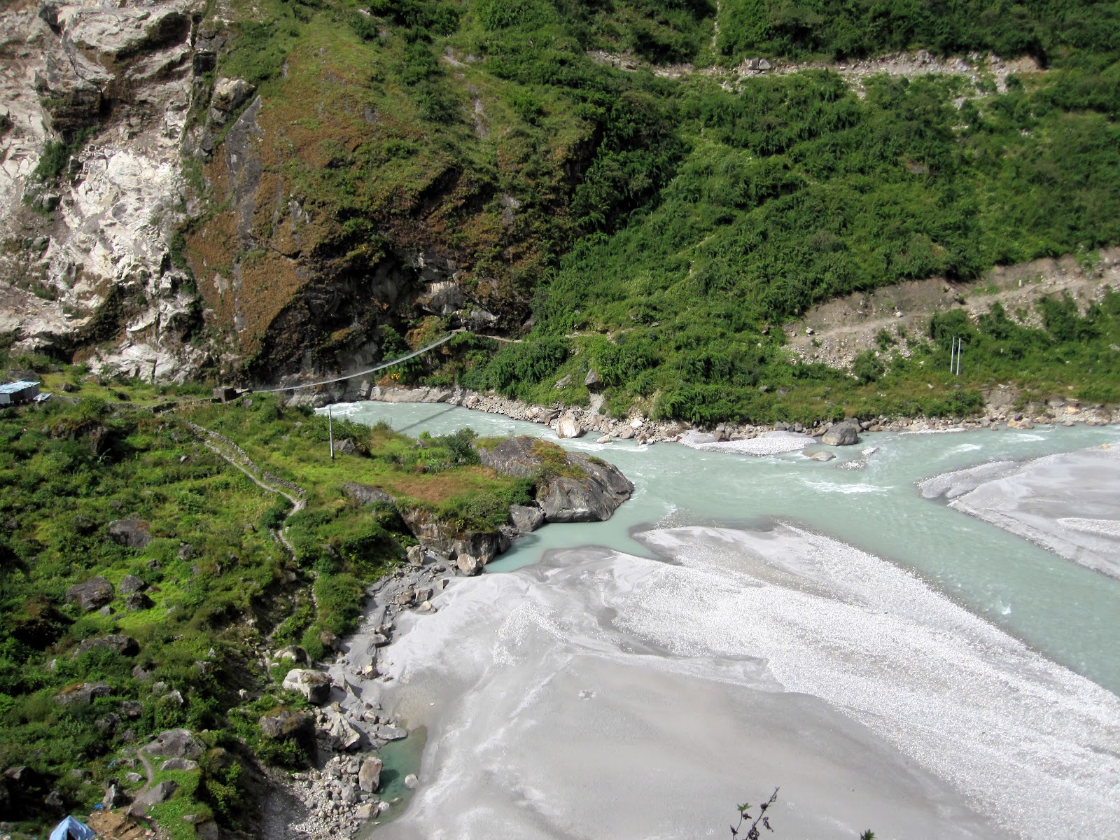
After arriving in Besisahar many people took another bus to Bhul Bhule instead of the 2 hour walk, a trend that would continue for most about 12 days later in Jomson. I chose to walk the entire circuit from start to finish. On the way to Bhul Bhule I came across the very first bridge of the trip, there would be many many more

and the 2nd bridge. I thought it would be a great idea to take pictures of all the bridges, but that soon passed. The same happened with waterfalls. Something is wrong when you can walk by a 100 foot waterfall and not stop to admire but I was spoiled quickly.

Nepal probably has the worst beer of anywhere I've ever been but Everest is my beer of choice.

DAY 2:

Sadly the clouds are out, this was the only day I walked in the rain. For the most part was blessed with clear skies, which is why October is the high season


 |
| Rice Fields |

They said their prayers and splashed 4 presumably holy items onto the goat. His time has now come.

Goal 1: Safrice (Check)

It is said to be bad luck if you don't get his head in one attempt. This village is blessed

ithin seconds the head was already taken into the house, not sure why. The goat kicked for a couple minutes. They drained his blood into a bucket. I never did see the snow leopard


 |
| Haters can hate, but the children love my umbrella hat |


DAY 3:


DAY 4:

Met this kid half way up a ridiculous switch back climb. His family had a tent set up selling warm Tibetan bread. If I did the same hike now I'd have no problems. Amazing how fast somebody as lazy as myself can walk myself into shape.

After the steep ascent we entered forests with pine trees. Pictures walking through the actual forest don't come out so great..

Also beginning to enter a region where the locals no longer speak Nepali, but Tibetan


Day 5: The night before I roomed with a Reins from Holland (above) in Chame (8,580 feet). He told me he had a feeling in the morning there would be blue skies. Oh boy was he right, when I opened the door in the morning a beautiful peak stared right at me. Look in other directions and there are a few more that had been hidden the day/night before. From here on it was ideal weather almost the entire way.
This is taken from the bridge exiting Chame. The Buddhist prayer flags make their appearance throughout the trek, especially in the Tibetan areas. They are usually comprised of 5 colors, representing the elements. They also contain both texts and images. I don't know much about them but assume they tell stories/myths about the Gods etc. but don't quote me on it
Blue- sky/space
White- air/wind
Red- fire
Green- water
Yellow- earth


The first day of nice mountain views.

There is a straight drop down to the left of the trail. The epicness of this doesn't convey well here
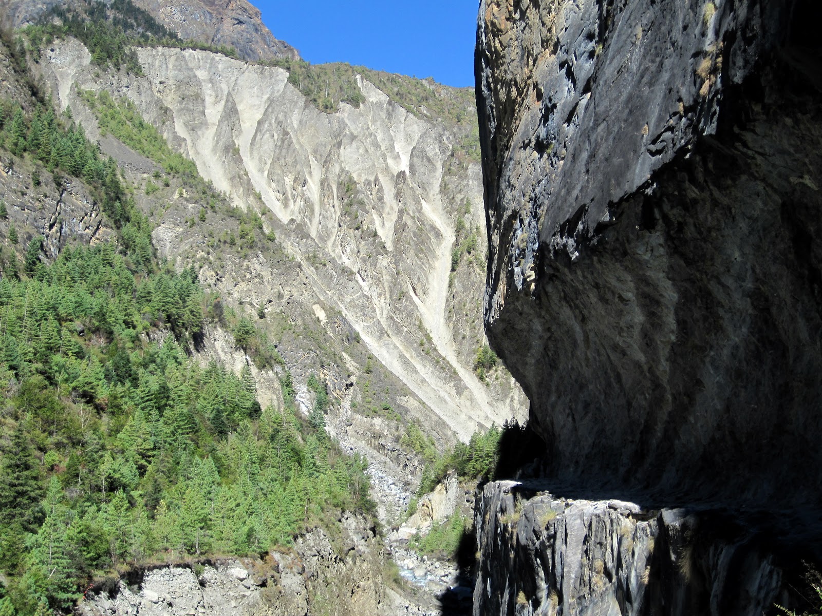
When exiting this section of the trail the environment makes a very noticeable change including seeing one of the most impressive and unique sites of the trip, the Paungda Ganda rock face. It shoots up 1500 m./4900 feet from the valley floor. Been told it is the result of glacial erosion


Porters are expected to be able to carry the bags for 2 people (up to 15kg each), plus their own belongings.

Don't know how much weight donkeys carry but everything in the villages is brought in by either donkeys or porters. One village several days away from the nearest road had a full size pool table. Had to wonder how the hell did that get here?


If anybody is reading this with plans to do the Annapurna Circuit I will make two recommendations. First, stay in Upper Pisang for two reasons. Your view from the guest house will be the best of the hike. Also, you are better off doing lower to upper the day before than starting the day with it as a steep climb awaits. Secondly, there are two options for the hike the next day, you can either do Upper or Lower and follow the river. If there are clear skies most definitely do the upper hike. This hike starts out with a serious switch back ascent but then it is smooth sailing. If you have a guide or porter they will not want to do Upper, most will refuse and I do not blame them. This is something that you must discuss with them when starting the trip. Don't let them prevent you from missing out on some of the best views of the hike and talk you into doing lower. It is also not fair to expect your porter to carry your pack on the upper route. If you have a porter offer to meet them at the end of the day in Manang. Personally, I did not have a guide or porter and carried my pack on the Upper Pisang route. It is no harder than going over the pass :)
Here is my view from the balcony in Upper Pisang (3300m./10,826ft), the most amazing I have ever had. Annapurna II (7,937 m (26,040 ft) is soo incredibly close though I don't think you can see the peak. Annapurna II is the 16th highest mountain in the world.


Another reason to stay in Upper Pisang is to visit the monastery.

DAY 6:As mentioned there are 2 options for day 6, upper Pisang or Lower Pisang. Upper begins with a massive climb and walks high above the river offering spectacular views. By sleeping in the Upper Village the night before we had already made the decision to do the upper hike which offered the most amazing views of the trek to date.
 |
| This is a serious climb. This women has definitely lived a hard life |

This is only about a 1/3 of the way up. At this point I realized why all the porters and guides were fighting with their clients on whether to do the Upper or Lower route. I had no guide or porter for the trek and carried my own backpack...This is about the point where you start to realize it is slightly harder to breathe due to the altitude. The prayer wheels in the picture above can be seen below

Still not to the top

 |
| More views of Annapurna II |


 |
| The first yaks of the trip! |


Day 7: Acclimatization day in Manang. 3519 metres (11545 ft).. Was supposed to do a day hike to a higher altitude and come back down to sleep but I rested for the day. Virtually everybody spends 2 nights here before moving on to higher elevations.
I did watch "Into Thin Air" in Manang. for anybody who has seen it or read the book, Anatoli died in 1997 climbing Annapurna I. The Annapurna mountain range is the deadliest in the world to climb due to how steep they are and avalanches. Over 50 people have died climbing Annapurna I alone. The success rate is much lower than Everest
Day 8:
 |
| Leaving Manang |


This is Yak Kharka, Tibetan for Yak pasture. Elevation 4018 meters/13,182 feet. At this point the villages are only lodging for trekkers and porters carrying goods between villages for the most part. Few people live above roughly 3500 meters. We stayed here, I am hiking up about a thousand feet after lunch in order to come back down and sleep in a successful attempt to avoid altitude sickness as I progress towards the pass. The previous 2 pictures are from the same afternoon hike up above the village. You can also see the river is becoming much smaller

Day 9: Hiked from Yak Kharka to the base camp of the pass. It was not a challenging hike but I struggled a lot. Every little climb I was short of breath
We woke up to snow in Yak Kharka

 |
| The trail was clear |


It was a steep climb to the 5,416/17669 meter pass

We stayed at the lower camp, this is the high camp (4926m/16,161 ft). Trail did even out some after this point

looking down on the high camp

Feeling high yet?


MADE IT!!! 5,416 meters/17,770 feet

Will end this post with the view of the other side of the pass


After the pass we descended about 1654 meters/5,500 feet down to Muktinah. Home to the first views of Dhaulagiri, the 7th highest peak in the world.
Amazing pictures of an amazing trek! I'm sooo jealous. One day, I'll go there.
ReplyDeleteThis comment has been removed by a blog administrator.
ReplyDelete